Home
All photographs Copyright © 2010 Jon R. Vermilye
To see a larger image, click on the photo
The New River Gorge Bridge & Babcock State Park, West Virginia
Fall, 2010
Home
All photographs Copyright © 2010 Jon R. Vermilye
To see a larger image, click on the photo
Other Pages:
Animals & Insects
Birds
Chipmunks
Flowers
Landscapes / Scenic
Lighthouses
New England & Nantucket
Oswego
Other Images
State & National Parks
Theatrical Images
Waterfalls, Page 1
Waterfalls, Page 2
Our 1996 Cross Country Trip
2001 PA Trip
Our 2004 Cross Country Trip
2010 Trip
Links to other waterfall
pages:
This will be my second trip to shoot waterfalls in the South (well, at least south of New York!) , and my 3rd trip to Ricketts Glen State Park. If you have been a viewer of my other pages, you will quickly discover that I enjoy photographing moving water, waterfalls in particular. Ricketts Glen is a wonderful place to photograph both. There are 22 named waterfalls in the park as well as two streams filled with cascades. I visited the park on a RV trip to Pennsylvania in 2001, and again last spring. In both cases, I felt the images would be better with the fall colors as a background. So, I planned a fall trip.
As long as I was heading south, I also decided to try to hit Babcock State Park in West Virginia for a fall visit (Spring 2010 trip to Babcock State Park) which contains one of the most photographed grist mills in the country. On the way I made a short stop at the bridge on US 19 crossing the New River Gorge, missing "Bridge Day" by a week. On "Bridge Day" they close the bridge, set up food & craft booths and allow base jumping from the bridge into the gorge below.
I also took a side trip to the Mabry Grist Mill along the Blueridge Parkway. The next part of the trip was driving the lower section of Skyline Drive. I met my daughter, her husband & granddaughter in Front Royal and followed them back to their home in Washington, DC.
That was the basic itinerary of the trip - I've divided it into sections so the same first section will appear in all of them.
Here is an index of the trip:
Day 1 Ricketts Glen
Page 2 of Ricketts Glen
Page 1 of New River Gorge & Babcock State Park - You don't need it - you are here!
Mabry Grist Mill & More of Babcock State Park
Skyline Drive & Washington, DC
Washington DC, Day 2
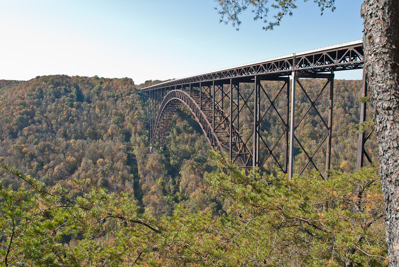
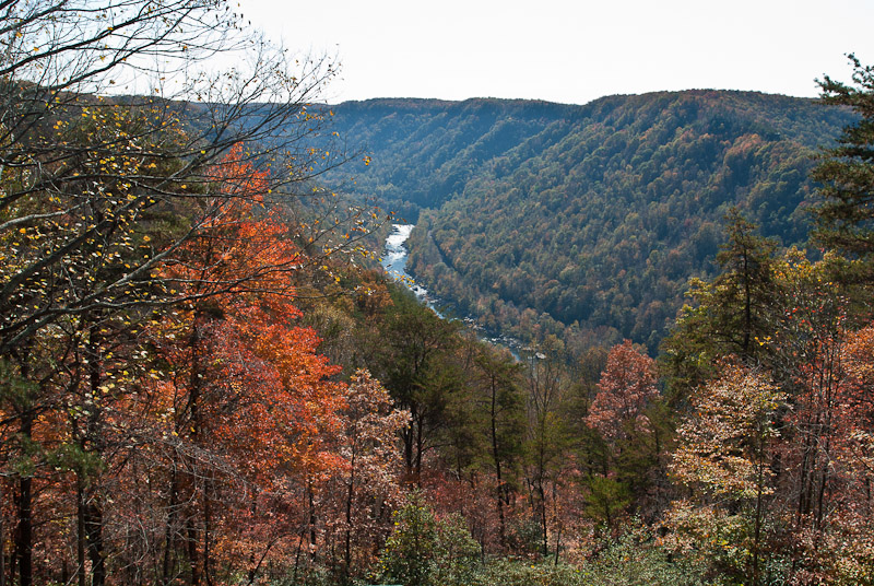
I got an early start from the Comfort Inn of Grantsville, MD & continued south following the GPS to Babcock State Park in West Virginia. Unlike the last trip I decided to use the interstates to save some time (and avoid car sickness - the last trip was on US 219, a beautiful road, but lots of curves, hills & valleys, etc.) I stopped on US Route 19 at the New River Gorge Canyon Rim Visitor Center to take a few photos of the bridge. If I had been a week earlier, not only would I have had better color, but I could have participated in an interesting local activity - Bridge Day. They close the bridge one Saturday each year to allow base jumping, food & craft booths, etc. Since I couldn't get away until this week, catching Bridge Day will have to wait for another year.
 |
 |
 |
 |
The Bridge |
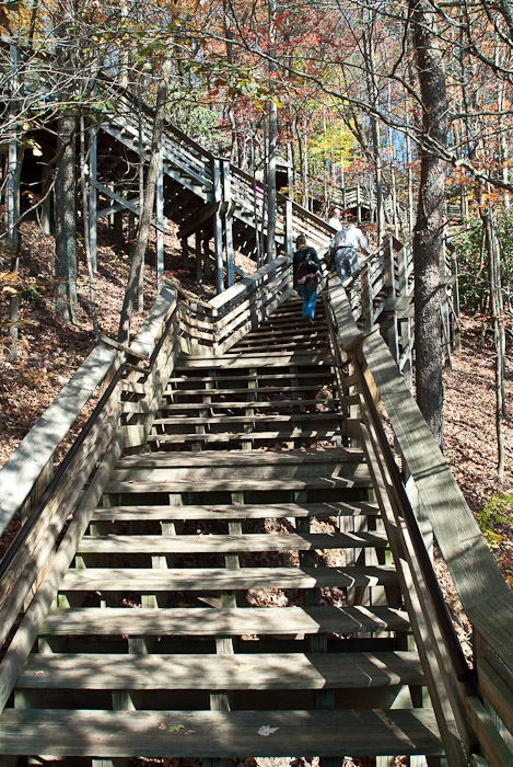
Stairs to the Viewing Area |
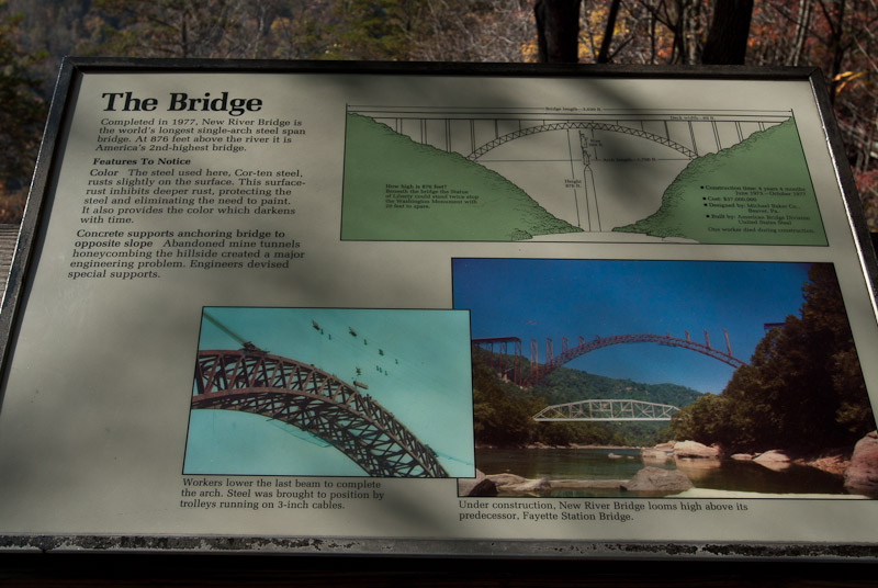
Information About Building the Bridge |
The View From the Visitor Center |
After a short stop at the bridge, I backtracked a few miles to US Route 60 and headed to Babcock State Park. I sure remember US 60 - it seems to go up & down every mountain in West Virginia. The color along the way was beautiful.
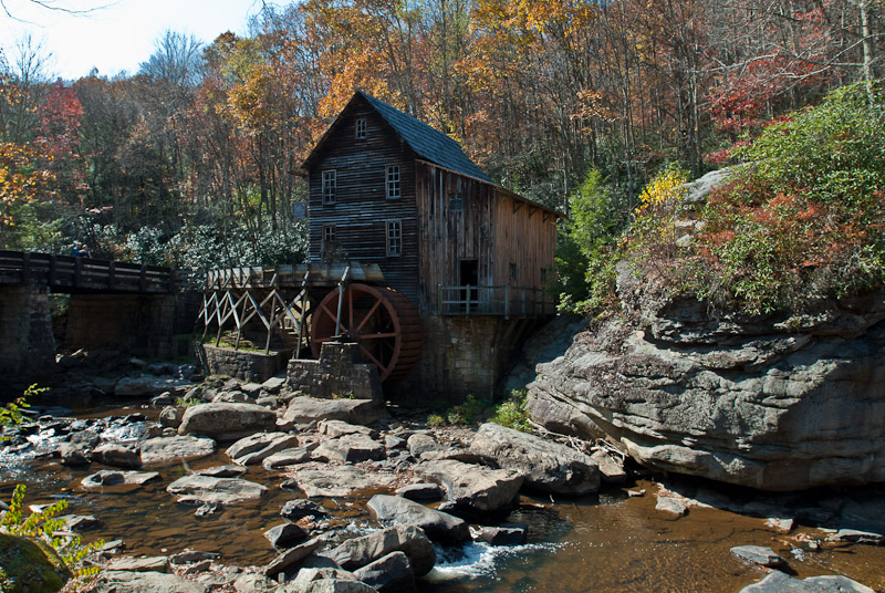
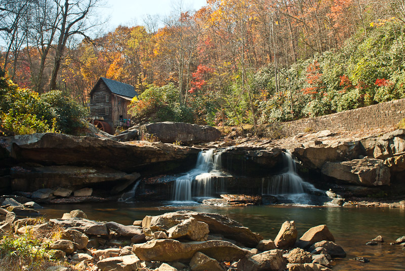
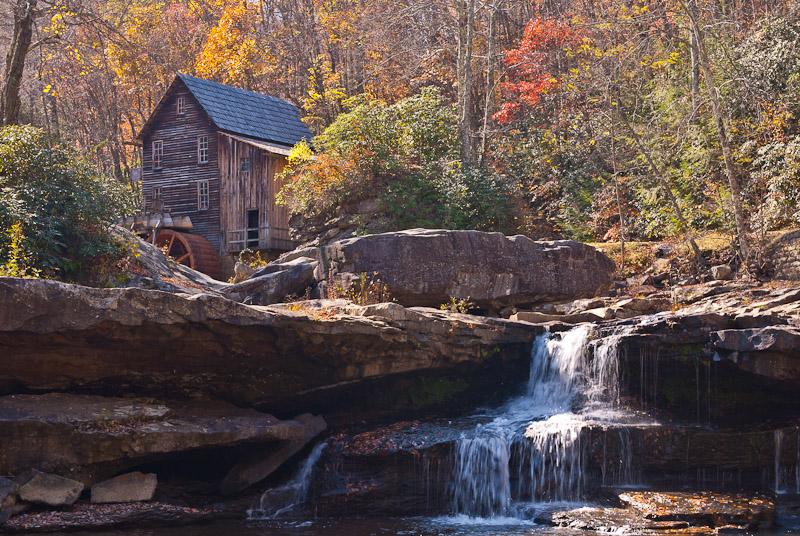
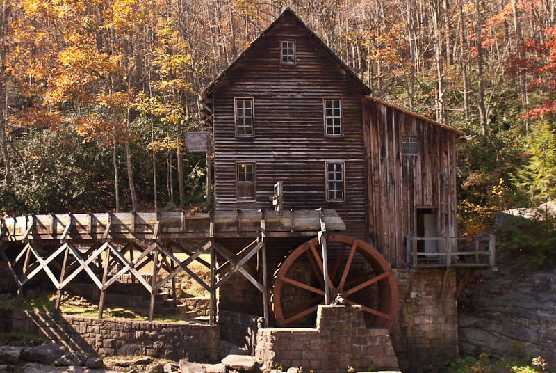
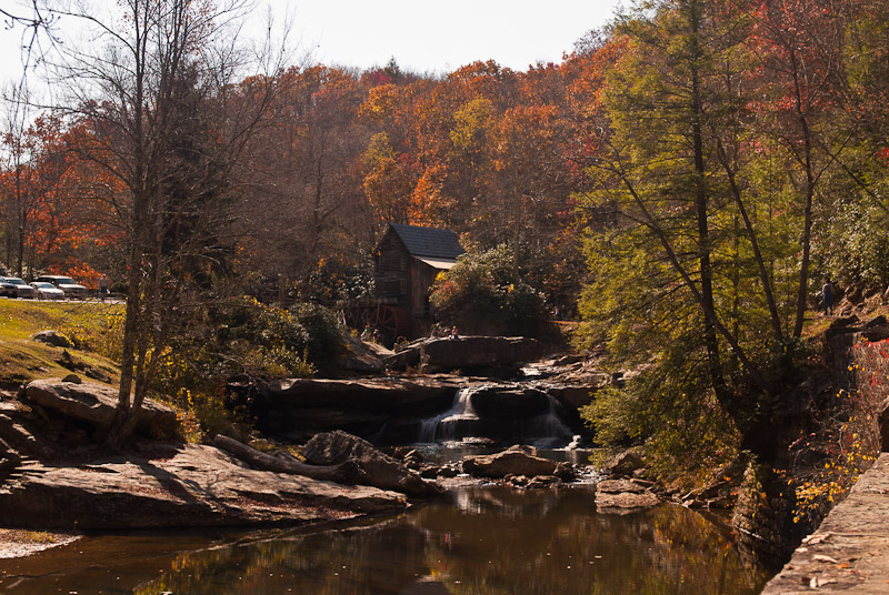
I reached the park around the worst time to take photographs - around noon, but decided to take a few before I went looking for a motel. The plan is to get a room close to the park, then head to the Blueridge Parkway to shoot some pictures of the Mabry Grist Mill , then back to the motel near Babcock & head out to the Babcock Glade Creek Grist Mill at sunrise on Sunday.
The grist mill on Glade Creek is a favorite of photographers any time of the year, but the fall seems to be the most popular time. I spent about an hour taking photos before doing a search on my Garmin GPS for the closest motel.
 |
 |
 |
 |
 |
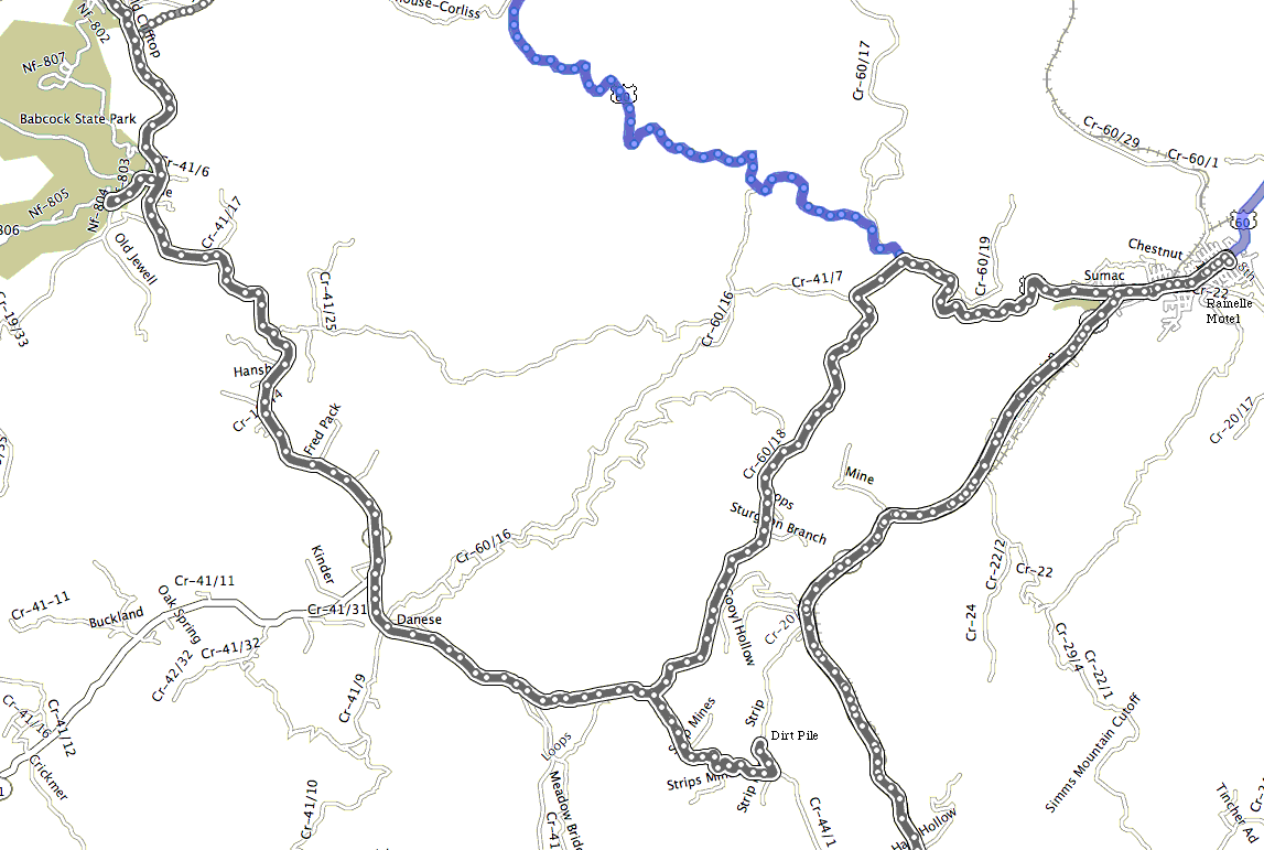
The Track From My Garmin GPS Showing the Road From Hell!
|
||
The GPS chose the Rainville Motor Lodge as the closest motel, and after paying far too much to sleep at the Comfort Inn, I decided a non-chain motel would be a good idea. So, with one punch of a button (well, actually a touch of a screen) I set off on the adventure of the trip; in fact, the adventure of the year, or even a couple of years! The Rainville Motor Lodge is on Main Street, which, if I had known at the time would have saved me hours & anguish, is US Route 60 (the route I took from US 19 to get to Babcock).
In any case, I left the park on WV 41 South started following the GPS directions. A left on County Rt 31, smaller, but still paved. Then onto Loops Road, which also seems to be County 60/18. Now, if I had a county map I would have discovered that County 60/18 goes all the way to US 60 which would be the way to go. Well, Ms. GPS said to take County Route 44/1, a gravel road.
The first part looked OK, so I went for it. BIG MISTAKE!!! It quickly turned to dirt, rocks, mud, etc. I was driving a RAV4 with all wheel drive, but it was a fairly new 2010 that survived 2 weeks on Nantucket, whose narrow, brush lined sand roads are famous for making what are called "Nantucket Pin Striping" scratches along the sides of the car. Although I did have one shopping cart ding, the car looked great. Now if I had any brains, I would have turned around at the first chance, but I kept thinking it can't get any worse, and the motel was only 8 miles away when I started down the road, so how bad can it be? Well, pretty bad. In many place it reminded me of the stagecoach roads I rode with friends out in Colorado where you had to drive around & over rocks, straddle ditches, etc.
I reached an intersection of 4 dirt roads, followed the GPS path down Strip Road. It showed .4 tenths of a mile to WV Route 20 (that I could see in the distance). Since WV 20 goes into Rainelle, it made sense to keep going. Only problem is after going around .3 tenths of a mile down a very steep rock strewn "road", I found a big pile of dirt blocking the way. While I sat there figuring out how to turn around a young man riding a ATV came over the mound with an expression that said "What the hell are you doing here & how did you get this far?" on his face. I got turned around, and waved him on since I didn't want to hold him up trying to get back up the hill. Using all my Nantucket back road skills, an incredible amount of luck, and all the ability of Toyota's RAV4, I managed to make it back up the hill. Thanks to the hospitality of West Virginians, the young man was waiting at the intersection to make sure I made it up the hill. We talked for a bit & he didn't have any better way out of the location than going back the 6 miles of bad road I drove through to get here, so it was back to WV Route 60/18 and on to US 60 into Rainelle.
All in all, it was quite an experience. The RAV 4 is no jeep, but it can deal with far worst road than I believed it could. I now have "West Virginia Pin Striping" on both sides, a bent trailer wiring connector mount, a missing hitch plug, and who knows how many dents in the underbody, but nothing seems to be leaking and the tires are still round! For anyone interested, I stuck a clip from Garmin Road Trip showing the roads and tracks of my drive in with the images above. Where the track ends a little right of center at the bottom is where the dirt pile was located. If you are really interested, the coordinates of where I was talked with the guy from West Virginia are 37° 54' 16.17" N by 80° 50' 11.84" W. Notice that Google Maps & Earth both show that Strip Road dead ends, but Garmin shows it going through. Time for a message to Garmin!
The Rainelle Motor Lodge had a adequate room for only $43.60, the least expensive (other than Karin's apartment) of the trip. I picked up the key & headed out to the Blueridge Parkway. According to the GPS the Mabry Grist Mill was about 3 hours from the motel (Yes, I'm still listening to is even after the last route!)! Although most of the way was on interstates, the leaves were in great color & I enjoyed the drive. The good part of the dirt road adventure is I was much later than planned when I reached the mill. It was about a half hour before sunset, and much better light than it would have been earlier.
This page is maintained by: vermilye@oswego.edu
Last Update:
March 21, 2012